


Mont Caly des perrières

Jamyfredo
User
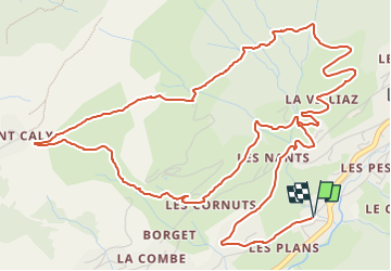

Length
9.6 km

Max alt
1492 m

Uphill gradient
406 m
Km-Effort
15 km

Min alt
1118 m

Downhill gradient
406 m
Boucle
Yes
Creation date :
2025-03-08 17:24:40.401
Updated on :
2025-03-08 17:26:52.453
1h00
Difficulty : Difficult

FREE GPS app for hiking
 SityTrail
IGN / Geographical institutes
SityTrail Plus
The world is yours!
About
Trail Running of 9.6 km to be discovered at Auvergne-Rhône-Alpes, Upper Savoy, Les Gets. This trail is proposed by Jamyfredo.
Positioning
Country:
France
Region :
Auvergne-Rhône-Alpes
Department/Province :
Upper Savoy
Municipality :
Les Gets
Location:
Unknown
Start:(Dec)
Start:(UTM)
318900 ; 5113206 (32T) N.
Comments